Seawater Intrusion of the Delaware River Basin
by Jacqueline Aybar, Lenny Calvo, Jeffrey Palm, Jhonatan Romero, and Kira Waldman
Hydrology of the Delaware River Basin
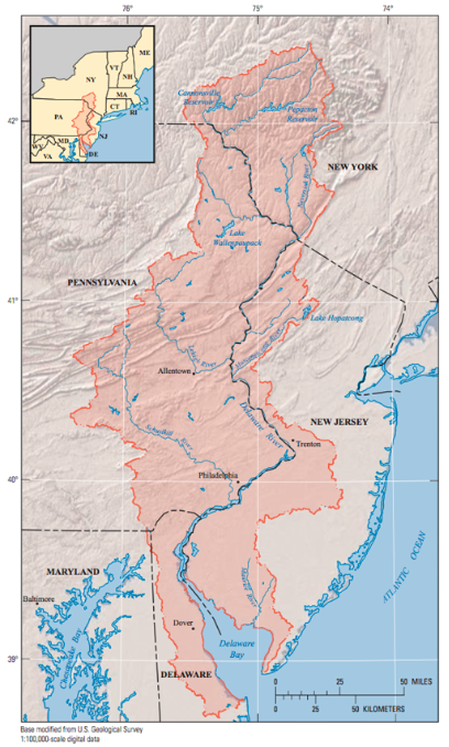
The Delaware River Basin (DRB) occupies two primary hydrologic regions. The first region in the upper basin is the Appalachian Highlands, which is dominated by consolidated sedimentary rock and hosts high energy streams and rivers. The lower basin is the Atlantic Coastal Plain, which represents a wedge of unconsolidated rock material that holds water within its deposits that feed lower order/intensity streams. The Atlantic Coastal Plain is the mouth to the Delaware Estuary, the final point of the basin before opening up to the Atlantic Ocean.
- The basin covers 12,800 square miles in parts of New York, Pennsylvania, New Jersey and Delaware
- 20% of the upper watershed lies within New York State alone
- The Delaware River is the longest undammed U.S. River east of the Mississippi River
- The deepest point of the Delaware is the Big Eddy at Narrowsburg, N.Y., at ~113 ft
- The Delaware Bay is the principal breeding grounds for American horseshoe crabs on the East Coast
Headwaters
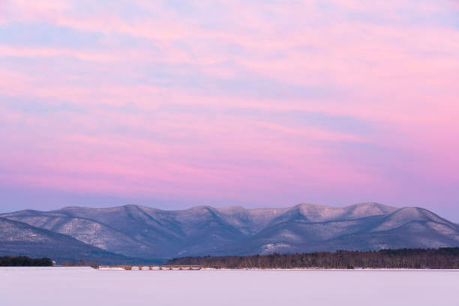
The headwaters of the Delaware River are in the Catskill Mountains in southern New York in the northern part of the basin. The Catskill Mountains receive an annual precipitation of about 50 inches of rain and 80 inches of snowfall.
Surface Water Flow
There are more than 2,000 freshwater tributary rivers (including 216 major ones) that feed the Delaware River. The largest of these tributaries are the Schuylkill and Lehigh Rivers, located in Pennsylvania. The target flow rate of the entire Delaware River is 3,000 cfs in order to maintain the Salt Front at a safe distance. These rivers are governed by different influences. North of Trenton, N.J to the headwaters in the Catskill Mountains, these 200 miles of river do not rise and fall with the tide. The southern 133 miles of surface water are tidal rivers - south of Trenton, N.J. to the Delaware Bay, the rivers rise and fall due to the tidal influences. Due to this dynamic system, the Delaware River has a rich history of flooding. There has been damage to the local floodplain and many of the tributary river’s floodplains. The two largest floods of record were in 1955 and 2004-2006. In August of 1955, there were two separate hurricanes that caused record flooding in the Delaware River. More recently, in 2004, the Tropical Allison caused $35 million in damages. The Delaware River is the longest (330 miles) undammed river east of the Mississippi River and is interstate along its entire length, meaning if you stand on one bank you always look across to another state!
Groundwater
Groundwater is a less robust contributor to the water demands of the Delaware River Basin, but still a fundamental part of the regional hydrologic cycle. The aquifers underlying the Delaware River Basin can be subdivided into two categories: (1) the deeper fractured rock aquifer in the northern basin and the (2) surficial aquifers underlain by unconsolidated sediments in the southern portion of the basin. The total groundwater withdrawal for these two aquifers is calculated to be 545 Mgal/day of freshwater (8% of the total daily demand).
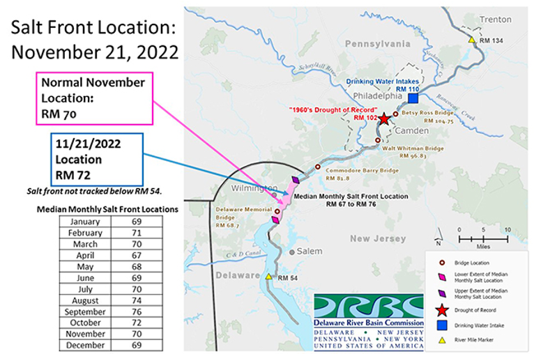
The Salt Front
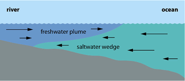
The Salt Front is the location of salinity intrusion in the Delaware Estuary that hits the 250 parts-per-million (or milligram-per-liter) chloride concentration based on drinking water quality standards. The Salt Front location is established using a seven-day average of concentrations to determine the line of salinity intrusion into the Delaware River Basin. Chloride concentration is the primary indicator of intrusion because it shows the degree that the chloride-rich saltwater has moved into the upper estuary. The freshwater from the Delaware River itself acts as the repellent to this salt intrusion, able to dilute the incoming seawater and establish lower concentrations of chloride. The Salt Front represents the point in the lower watershed, which the freshwater inflows cannot dilute the intruding seawater to a healthy and sustainable level for the river system. The intruding Salt Front not only advances up the river system, but saltwater contaminates the aquifers as the sea continues to rise and coastal communities pump groundwater at an unsafe and unsustainable rate.
References
- A tranquil winter view looking west toward the Burroughs Range of New... (n.d.). IStock. Retrieved November 22, 2022, fromhttps://www.istockphoto.com/photo/sunrise-over-burroughs-range-of-catskill-mountains-in-winter-gm1199984203-343544258
- Delaware River Basin Commission|DRB Info for Students & Teachers: Fun Facts About the DRB. (n.d.). Retrieved November 22, 2022, from https://www.state.nj.us/drbc/public/outreach/fun-facts.html
- Estimated Ground-Water Availability in the Delaware River Basin, 1997-2000. (n.d.). Retrieved November 22, 2022, from https://pubs.usgs.gov/sir/2006/5125/
- Hutson, S. S., Linsey, K. S., Ludlow, R. A., Reyes, B., & Shourds, J. L. (2016). Estimated use of water in the Delaware River Basin in Delaware, New Jersey, New York, and Pennsylvania, 2010. In Estimated use of water in the Delaware River Basin in Delaware, New Jersey, New York, and Pennsylvania, 2010 (USGS Numbered Series No. 2015–5142; Scientific Investigations Report, Vols. 2015–5142, p. 88). U.S. Geological Survey. https://doi.org/10.3133/sir20155142
- Hydrology.pdf. (n.d.). Retrieved November 22, 2022, from https://www.state.nj.us/drbc/library/documents/SOTB/hydrology.pdf
- Philadelphia District & Marine Design Center > Missions > Civil Works > Delaware River Basin Comprehensive Study > History of Delaware River Flooding. (n.d.). Retrieved November 22, 2022, from https://www.nap.usace.army.mil/Missions/Civil-Works/Delaware-River-Basin-Comprehensive-Study/History-of-Delaware-River-Flooding/
- USGS Report.pdf. (n.d.). Retrieved November 22, 2022, from https://pubs.usgs.gov/fs/1999/0056/report.pdf
Management of the Delaware River Basin
History of DRB Management
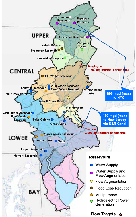
Being a plentiful source of freshwater within a close proximity to major population centers, the Delaware River has been the source of interstate conflict over water rights for decades. The watershed is a major source for New York City (NYC), which sits outside of the Delaware River Basin. In 1931, New Jersey brought a suit against the state of New York and NYC before the Supreme Court over NYC’s diversions from the watershed. The Court authorized NYC to divert up to 440 MGD, in a consent decree to five parties (Decree parties): The City of New York and the States of Delaware, New Jersey, New York, and Pennsylvania. This decree was amended in 1954 with a motion from NYC looking to increase its allotment from the Delaware River watershed. The 1954 amended decree went farther in laying the groundwork for Delaware River Basin Management when it established the following (Gov’t of N.J.):
- 800 MGD allocated to NYC after the completion of all three of its reservoirs in the Delaware River Basin
- 100 MGD allocated to New Jersey to be diverted through the Delaware and Raritan Canal
- An Excess Release Quantity (ERQ) to be released from reservoirs in the headwaters each year
- Required compensating releases to maintain a minimum flow target of 1750 cfs at Montague, New Jersey
- The creation of the Office of the Delaware River Master (ODRM) to oversee many of these requirements
Conflicts and shortages would remain, however, leading the governors of states in the Delaware River Basin and President John F. Kennedy to sign a compact leading to the formation of the Delaware River Basin Commission (DRBC). The Commission members consist of the governors of Delaware, New Jersey, New York, and Pennsylvania, and the North Atlantic Division Engineer for the U.S. Army Corps of Engineers (USACE) to represent the federal government. The DRBC represented a revolutionary new step in collaborative water resource management, where all members have equal say.
The next landmark decision came when the Decree parties gave a recommendation to the DRBC, also known as the “Good Faith Agreement” that, among many other things, set a new minimum flow target for 3000 cfs at Trenton, N.J. and placed responsibility for maintaining those flows on NYC by releases from its DRB reservoirs. (USGS Delaware River Master) Since then, the DRBC also utilizes reservoirs owned by the USACE in Pennsylvania to help regulate flow.
Flow Management
The ODRM is a position within the U.S. Geological Survey (USGS) founded to oversee some of the requirements of the 1954 decree. These responsibilities include:
- Administering the provisions of the Decree relating to yields, diversions and releases
- Conserving the waters of the river
- Compiling data on the water needs of the parties
- Checking and correlating streamflow measurements and records
- Observing, recording, and studying the effect of developments in the watershed on water supply and other uses
- Making periodic reports to the [Supreme] Court (USGS Delaware River Master)
In 2017, the 1954 Decree party members approved a Flexible Flow Management Program (FFMP2017) to meet water supply demands, protect fisheries habitat downstream of the NYC reservoirs, enhance flood mitigation, and repel the upstream movement of salt water in the Delaware Estuary. (USGS Delaware River Master) The ODRM and other agency representatives are currently engaged in a salinity study to consider different approaches to maintaining salinity at the mouth of the DRB, including:
- New flow objectives
- New storage
- Reallocation or optimization of current storage
- Augmentation releases from the upper and lower basin reservoirs
The motivation of the study is to consider alternatives in the event that NYC reservoir releases are no longer used for the purpose of repelling the salt front (USGS Delaware River Master).
The DRBC formed its Advisory Committee on Climate Change (ACCC) in 2019 to address potential effects of climate change on water quality and flow regimes on the river and how the DRBC can prepare for and respond to these changes.
References
- Delaware River Basin Commission|Flow Management. (n.d.-a). Retrieved November 23, 2022, from https://www.nj.gov/drbc/programs/flow/decree.html
- Delaware River Basin Commission|Flow Management. (n.d.-b). Retrieved November 23, 2022, from https://www.nj.gov/drbc/programs/flow/flow-mgmt.html
- Ravindranath, A., Devineni, N., & Kolesar, P. (2016). An environmental perspective on the water management policies of the Upper Delaware River Basin. Water Policy, 18(6), 1399–1419. https://doi.org/10.2166/wp.2016.166
- Rupert, C. D. (2014). The Delaware River Basin Commission: A Unique Partnership. Water Resources IMPACT, 16(5), 3–6.
- USGS Delaware River Master. (n.d.-a). Retrieved November 23, 2022, from https://webapps.usgs.gov/odrm/
- USGS Delaware River Master. (n.d.-b). Retrieved November 23, 2022, from https://webapps.usgs.gov/odrm/ffmp/flexible-flow-management-program
Impacts to Coastal Ecosystems
Habitat
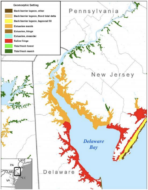
The coastal habitat of the Delaware River Basin includes a variety of wetlands, including coastal marshes. These marshes provide a multitude of benefits, such as a coastal storm buffer, erosion prevention, nutrient absorption and water filtration, carbon sequestration, and essential wildlife habitat. As sea levels rise, this coastal marsh habitat becomes increasingly threatened. Rising sea levels may inundate the marsh habitat, resulting in losses of habitat ranging from 14.6% to 99.6% inundation depending on the degree of sea level rise (DRBC 2021). In addition, rising sea levels may increase erosion and migrate coastal wetlands further inland.
The potential loss of coastal marshes could exacerbate climate change impacts in the Delaware River Basin. Without this natural storm buffer, the region faces a greater flood risk with more extreme storm surge events. In addition, this would result in the loss of previously mentioned natural benefits from the marsh, further escalating the problem.
Species
As previously mentioned, sea level rise may reduce coastal wetland habitat, which directly threatens local species. Over 200 species of migratory and resident fish, as well as shellfish and birds depend on the Delaware Estuary (Kreeger et al. 2006). This includes species listed under the Endangered Species Act (ESA) such as the Atlantic sturgeon, which is predicted to lose spawning habitat in the region due to sea level rise and intensified drought (Breece et al. 2013).
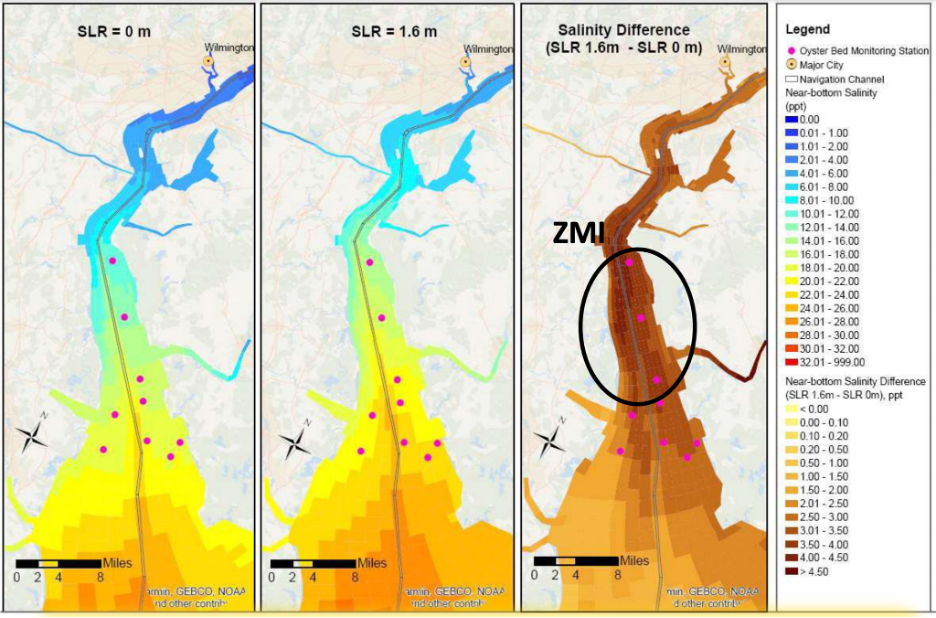
Along with these direct impacts to species from habitat loss, the salinization of the estuary may also introduce novel predators. As demonstrated in Figure 6, sea level rise will cause a salinity increase, impacting several oyster beds. This becomes particularly problematic, as predators such as oyster drills are likely to become more prevalent at higher salinities, creating additional predation (DRBC 2022). This pattern is likely to be observed among other species, providing implications for species interactions.
References
- Sea Level Rise Impacts on Delaware Estuary Wetlands
- Potential Impacts of Sea Level Rise on Salinity in the Delaware Estuary
- Breece, M. W., Oliver, M. J., Cimino, M. A., & Fox, D. A. 2013. Shifting distributions of adult Atlantic sturgeon amidst post-industrialization and future impacts in the Delaware River: a maximum entropy approach. PloS one, 8(11), e81321.
- Kreeger, D., Tudor, R., Sharp, J., Kilham, S., Soeder, D., Maxwell-Doyle, M., ... & Klein, K. 2006. White paper on the status and needs of science in the Delaware Estuary. Partnership for the Delaware Estuary.
Impacts to Coastal Communities
Agencies, such as the Delaware Department of Natural Resources and Environmental Control (DNREC), are tackling environmental justice issues following Executive Order 12898. The executive order stated that agencies must consider environmental justice in their plans and respond to "disproportionately high and adverse human health or environmental effects of its programs, policies, and activities on minority populations and low-income populations'' (Roe et al., 2003). As a result, the DNREC created the Community Involvement Advisory Committee who are responsible for implementing strategies to follow Executive Order 12898.
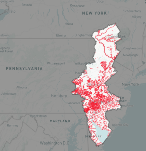
Other programs to help environmental justice in the basin include the US Fish and Wildlife Services’ Delaware River Restoration Program. The program was established shortly after the passing of the 2016 Delaware River Basin Conservation Act. The act, in addition to establishing the Restoration Program, focuses on the following areas: “conserving and restoring fish and wildlife habitat, improving and sustaining water quality, upgrading water management and reducing flood damage, enhancing recreational opportunities and public access”. Examples of locations of interest are shown in Figure 7 above. Figure 7 shows a map of impaired waters which are defined as water bodies that are not compliant with the Federal Clean Water Act.
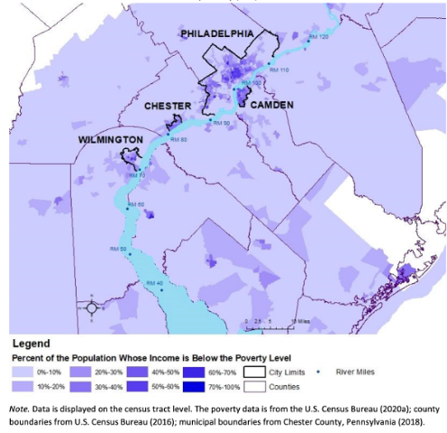
income in below poverty level
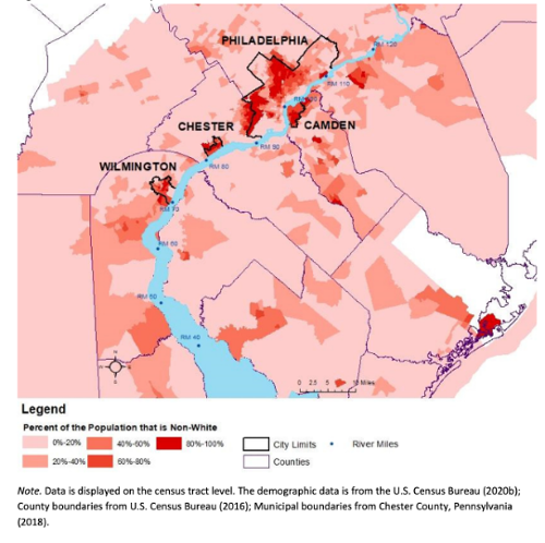
Even though there are programs in place to help those who do not have a say, there are still going to be people who are excluded in the decision making. As previously mentioned, there are programs to help create better recreational areas for people to enjoy and improve the water quality within the DRB for better quality of life. The mission of these programs are precisely what environmental justice is about. However, along the DRB, there are areas of poverty that are “near the most degraded portions of the Delaware River'' (Alkire et al., 2020). Cities in these areas include Camden, Philadelphia, Chester, and Wilmington which are shown in Figures 8 and 9. The relation between these figures is that the cities mentioned above contain “some of the region's largest concentrations of minority populations as well as lower household and per capita personal income levels compared to metropolitan and state averages” (Alkire et al., 2020).
These figures show that the areas with lower per capita income are experiencing poor water quality which is an environmental justice issue that the programs mentioned above should focus on.
References
- Alkire, C., Silldorff, E. L., &; Wang, S. (2020, December). Economic Value of Dissolved Oxygen Restoration in the Delaware Estuary. Delaware River Keeper. Retrieved from https://www.delawareriverkeeper.org/sites/default/files/DRN%20Keylog%20-%20Economic%20Value%20of%20DO%20Restoration%20in%20the%20DE%20%282020-12%29.pdf
- Delaware River Basin Map. (n.d.). Retrieved November 23, 2022, from https://www.delawarewatershed.org/#/map
- Delaware River Basin Restoration Act: U.S. Fish & Wildlife Service. FWS.gov. (n.d.). Retrieved from https://www.fws.gov/law/delaware-river-basin-restoration-act
- Delaware River Basin Restoration: U.S. Fish & Wildlife Service. FWS.gov. (2022, August 25). Retrieved from https://www.fws.gov/program/delaware-river-basin-restoration#:~:text=The%20Act%20established%20the%20Delaware,management%2C%20and%20reducing%20flood%20damage
- Roe, A., Inniss, V., Luna, M., Graham, E., Maragia, D. B., Smizik, S., ... & Assembly, D. G. (2003). COMMUNITY ENVIRONMENTAL PROFILES–ATool FOR MEETING ENVIRONMENTAL JUSTICE GOALS: An Analysis of the City of Wilmington. Center for Energy and Environmental Policy, College of Human Services, Education and Public Policy, University of Delaware.
Climate Predictions
Human Impact → Lower Freshwater Availability
Because of the human impact on the environment through rapid development, specifically accessing freshwater systems along the DRB, combined with the climate change effects from human impact as well, saltwater intrusion is expected to increase, lowering the quantity of freshwater access overall, and create some adjustments to the current land surrounding the DRB.
Rapid development contributes to an increase in water demand and in crop irrigation which decreases the freshwater replenishment, thus threatening the equilibrium that holds saltwater back from entering further into the basin. With more extreme weather events such as: unprecedented storms, long droughts, more inland flooding and sea level rise, this will make saltwater inevitably contaminate aquifers - as more unsustainable amounts of groundwater are used up.
Researchers at Florida State University claim that “The ‘salt front’ of the tidal saltwater wedge in coastal rivers will move further upstream, with the potential to affect both surface water intakes and well fields that are recharged with river water.” (Hurdle, 2020)
Lower Freshwater Availability → Effects on the Land
The Mid-Atlantic coast between New York and Virginia is sinking at the same time that ocean level is rising. In a New Jersey sea level rise report from 2019, the projection for New Jersey anticipated coastline, is expected to rise up about 1.1 - 3.5 feet by 2070. (Source: NJ sea level rise reports)
Because of the escalation in the salt front, researchers say there is a large potential to have a record drought, once reservoir storage is used up to meet the added demand. (Gordon 2019)
Additionally, this will damage the ecology of the estuary. Danielle Kreeger - senior science director for the Partnership for the Delaware Estuary stated “Eventually we are going to hit another drought, and you’re not going to hit those water flow targets very easily” - following up that protecting ecological freshwater systems will be of less importance, once the cities of Philadelphia or New York need more water, inevitably leaving ecological maintenance as low priority. (Gordon 2019)
Methods to Address Land Changes
One method Planners are considering for combatting the seawater intrusion, is to release more water from upstream reservoirs, in order to keep the same volume of water downstream, this would keep the same pressure on the salt front, stopping it from encroaching closer. A current example of what could happen with seawater intrusion progressing, is the saltwater intrusion of the Biscane Aquifer in Southeastern Florida. Control structures were built to hold back inbound seawater but will only last until about the mid-2030s.
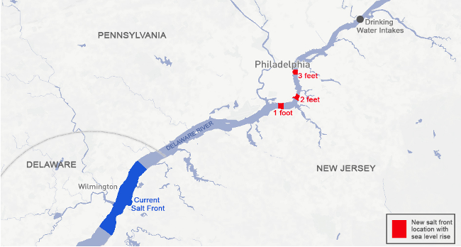
In the 1960’s there was a 6-year drought which pushed the salt front to river mile 102, which was about 8 miles downstream from key water intake in Philadelphia. Ever since, sea levels have been rising still, and are expected to surge in the coming decades. In response to this major drought, the DRBC created a flow management plan to control the water - if the river flow is low, officials of the DRBC will boost the volume of water flowing downstream from 3 main reservoirs in upstate New York.
Overall, the advancing salt fronts threaten drinking water supplies today, they are reducing our quantity of drinking water availability, lowering land elevation, increasing maintenance needed on freshwater ecological systems all of which is forcing the DRB community to come up with fast solutions before we experience any harsher consequences of seawater intrusion.
References
- Bataille, Amber, et al. “Salt in Our Water - Saltwater Intrusion and Inundation in Delaware - DNREC Alpha.” DNREC Alpha, https://dnrec.alpha.delaware.gov/outdoor-delaware/salt-in-our-water/. Accessed 23 Nov. 2022
- Gordon, Laura. “NJ Sea-Level Rise Reports.” Rutgers Climate Institute, 2019, https://climatechange.rutgers.edu/resources/climate-change-and-new-jersey/nj-sea-level-rise-reports.
- Hurdle, Jon. “As Sea Levels Rise, Will Drinking Water Supplies Be at Risk? - Yale E360.” Yale E360, 23 Apr. 2020, https://e360.yale.edu/features/as-sea-levels-rise-will-drinking-water-supplies-be-at-risk.
- Hurdle, Jon. “As Sea Levels Rise, Will Drinking Water Supplies Be at Risk? - Yale E360.” Yale E360, 23 Apr. 2020, https://e360.yale.edu/features/as-sea-levels-rise-will-drinking-water-supplies-be-at-risk.